Exploring the route of the old Dyke Railway: Part II
As the team make their final preparations they hear news from the other end of Brighton that, a-man- (and-his) son, who had originally planned to explore the route of the old Kemp Town Railway, at the last minute change their plans and also head for the Dyke Station! However the team won’t allow this to affect their plans. “Ours is not a race to be first to reach the old station, ours is an expedition of historic, scientific and geographical importance”, expedition leader Pete explains. “If we also reach the Dyke Station first, it will be a bonus!”
1st stop Aldrington Halt
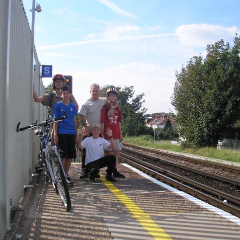
On the afternoon of Sunday 14th September 2008 the boys all meet at Aldrington Halt, the start of the expedition. It’s a beautiful late summer afternoon, with a temperature of 23°C and clear blue skies, perfect conditions! Pete has the teams’ supplies in his back-pack, cold drinks and chocolate bars, while Tiarnan the technician has the laptop.
Reality and virtual evidence
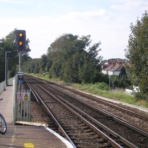
Unfortunately viewed from the platform of Aldrington Halt, little if any evidence of the old railway can be seen. The boys search both platforms and each end, but there is nothing to be seen. Teirnan boots up the laptop and recommends Microsoft Virtual Earth http://maps.live.com as the best website for aerial views of Brighton. As soon as he logs-on the boys all agree, as the sharpest ever virtual views of Brighton appear.
Checking old maps
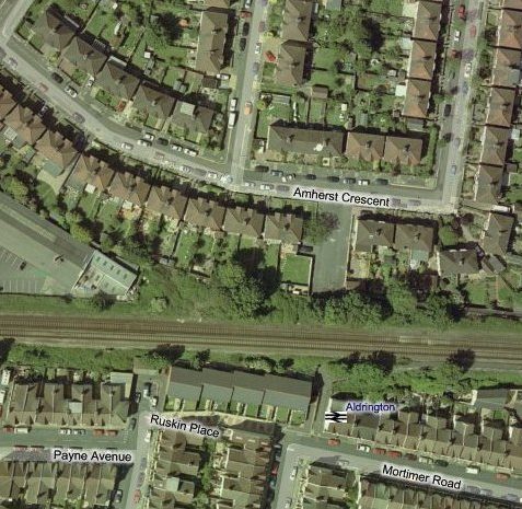
They home in on the Aldrington area, and, along with the old maps, it quickly becomes easy to see that the Dyke Railway line left the main south coast line directly behind Ruskin Place. The back gardens of Amhurst Crescent, just to the north-west of the small tunnel under the line, stop short of the coast line. It’s on this triangular area of land, which is densely covered with undergrowth, that the branch line left the main coast line. Additionally it’s also clearly apparent that the factory building has taken its alignment from the old junction!
Dyke Railway history
When the Dyke Railway opened on September 1st 1887 there was no station at the junction. Passengers bound for the Dyke, which was the only station on the line, had to board at Brighton or West Brighton, which was opened as Cliftonville in 1865, renamed West Brighton in 1879, and renamed Hove in 1895. On September 3rd 1905 Dyke Junction Halt was opened, almost exactly eighteen years after the line had opened. By this period ‘Poets Corner’ had developed north of Portland Road. The new halt consisted of simple wooden platforms, and a siding to the north for Hove Electric Lighting Company. Dyke Junction Halt was renamed Aldrington Halt on June 17th 1932.
Expectations of the journey
Unlike Brighton, there is a gradual incline inland from Hove seafront, and Aldrington Halt lies at approximately 70 feet above sea level. With the terminus of Dyke Station 500 feet above sea level, there is still over 400 feet to go. Using the ‘tools’ and ‘measure’ feature on Google Earth, Tiarnan measures the distance ‘as the crow flies’ and finds its exactly 3 miles, however the boys expect their ‘investigative’ route will be much further!


Comments about this page
An excellent project. I’ve walked to The Devil’s Dyke many times from Portslade via the now defunct West Hove Golf course but only once via the old railway line from Hangleton Church. If I could suggest a slightly better mapping tool below… http://www.flashearth.com/?lat=50.87722&lon=-0.209283&z=16.1&r=0&src=msa …although still about four years out of date, according to my property, it does give a very good Lat/Long readout which tallies exactly with readings I got from a Garmin SatNav device. I think I’ve centered the map over where the old Dyke Station used to be. Regards
It is sad that it appears that someone may have heard of your venture and be setting out to steal your thunder. Good Luck.
This is gonna be a slow journey to the Dyke unless Part 3 comes online soon!
Holland Road Halt was opened in 1905 with trains stopping there too. There was another station on that site before then but it was closed in 1880 before the Dyke railway opened. However this was after the acts were passed in Parliament, so it may be referred to in the acts. Interestingly that station was called Hove Station, not to be confused with what is now Hove Station but back then, as stated in this interesting article, was called Cliftonville Station. I took the station opening dates from the excellent ‘The Directory of Railway Stations’ by R.V.J. Butt.
Hi I used to live in Maple Gardens and spent the first 10 years of my life playing on and around the old railway bank. We were at No 26 and my grandparents had extended our back garden to incorperate the north slope of the railway bank. The first half was a vegetable garden and the steep part had a windy path to the top. We used to pick blackberryies by the basket full and had large bonfires on November 5th each year where the tracks used to be. We also had access down the south side of the bank to Englishes market garden. I have many more happy memories of the old railway bank and was very sad when they removed it to build the fire station.
Hi Ken, and many thanks for the comments you have made. You mentioned “bank” which implies an embankment, and at first I thought you must be mistaken, “he means cutting” Anyway I got the old 1933 OS map out and it looks like the cutting under Old Shoreham Road soon changed from cutting to embankment as it reached Maple Gardens. Of course on the old map its not possible to see the difference between cutting and embankment, great if you could confirm?
Oh, Ken also I would be interested to know when you lived at No 26, between what years? Thanks.
My understanding is that after passing under the Old Shoreham Road in a deep cutting the line quickly changed to an embankment and it is this embankment which I believe Ken is referring to and which can be seen in images 125 and 146 (volume 16) of James Gray’s photos. This embankment is now of course the site of Hove Fire Station. What I think is really interesting about image 146 in particular, is that it clearly shows the rising gradient of line at this point.
Thanks for that Stu, I had see those photos before, but had dismissed them as not very interesting, I was wrong. I can’t quite make out the exact location/position of each photo (125 and 146), although I’ve the general position, I wouldn’t mind a visit to see if I can identify the exact current view from the same location, many thanks.
Hi Peter! I lived at No 26 from 1950-1960. My grandparents’ name was Pennicard, they brought the house in the mid 1930s not long after it was built. My grandad died in 1960, my grandma lived there until 1963 and then sold up and moved away. Under the shed/garage was a large airaid shelter, in later years it was filled with rubbish, old bikes etc. As a child I can remember an old hand gun from the war being thrown down there. Yes, I spent many many happy days of my childhood “up on the Bank”. At number 26 there was a large crack down the stair case wall - my mother says it was caused when a bomb went off near by in the war; it only showed when the wall paper on the stairs was changed. I am adding a photo of my Dad and Grandad standing were the car park for the fire station is now. Ken.
Hi Ken, thanks for that! Where is the photo of your grandad? Perhaps you could email it to me pedrogroves@googlemail.com
I enjoyed reading of the children exploring the old line. In the late 20s I had a season ticket to travel to school at East Hove Infants School traveling by train which was always the old push-pull Dyke train, the engine in the middle, returning in the afternoon from Holland Road Halt. By 1929 I had become the train prefect, maintaining order amongst the younger children. One of the sights was seeing the signalman step out from his signal box to hand over the metal ring that every train on the Dyke railway had to have.
Hi George, brilliant to have a first- hand recollection of someone who actually remembers travelling on the Dyke line. The metal ring you referred to is the single line token that the signalman would have passed to the driver at Dyke Junction which permitted him access onto the single track branch line. Do you have any other recollections, photos or stories that you can share with us please as I’m sure they’d make fascinating reading for those of us interested in the line?
Add a comment about this page